


mont noël courte 6km

coglais
Gebruiker

Lengte
6,2 km

Max. hoogte
168 m

Positief hoogteverschil
69 m
Km-Effort
7,1 km

Min. hoogte
126 m

Negatief hoogteverschil
70 m
Boucle
Ja
Datum van aanmaak :
2016-11-04 00:00:00.0
Laatste wijziging :
2016-11-04 00:00:00.0
1h40
Moeilijkheid : Medium

Gratisgps-wandelapplicatie
 SityTrail
IGN / Geografische instituten
SityTrail Plus
De wereld gaat voor u open
Over ons
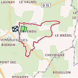
Tocht Noords wandelen van 6,2 km beschikbaar op Bretagne, Ille-et-Vilaine, Les Portes du Coglais. Deze tocht wordt voorgesteld door coglais.
Beschrijving
même départ circuit montnoël échelle et variant par le GR 34 vers Montours
Plaatsbepaling
Land:
France
Regio :
Bretagne
Departement/Provincie :
Ille-et-Vilaine
Gemeente :
Les Portes du Coglais
Locatie:
Montours
Vertrek:(Dec)
Vertrek:(UTM)
625231 ; 5366978 (30U) N.
Opmerkingen